
Bozeman, Montana
University town with ski hills on both sides and Yellowstone down the road.
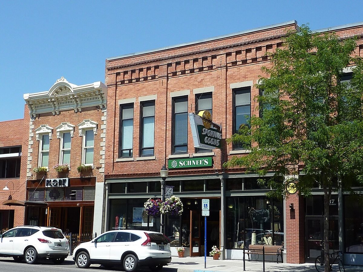
Photo: Main Street, Bozeman: photo by Chris06, CC BY-SA 3.0, via Wikimedia Commons, resized. All photo credits.

Last updated: October 28, 2026
Part of our Montana towns guide. Planning a park trip? See Yellowstone from Montana.
Disclosure: We may earn a commission if you use some links on this page, at no extra cost to you.
Bozeman is the county seat of Gallatin County (Montana Association of Counties), the home of Montana State University, and the home of a year-round commercial airport that serves Yellowstone’s North and West entrances. The town sits at about 4,810 feet in the Gallatin Valley. Downtown is roughly 78 road miles (about 1 hr 30 min) from Yellowstone’s North Entrance at Gardiner and about 300–330 road miles (roughly 6 hours) from Glacier National Park’s entrances, so Bozeman is a Yellowstone base, not a Glacier one.
This page covers the quick facts people search for, then what living in or visiting Bozeman looks like: getting here, getting around, things to do, weather and costs. For the full money picture, see Cost of Living in Bozeman.
Bozeman quick facts
| Fact | Answer | Source |
|---|---|---|
| County | Gallatin County (county seat) | USGS GNIS (feature 769173); Montana Association of Counties |
| Elevation | About 4,810 ft at the town’s official map point | USGS Elevation Point Query Service at the GNIS point |
| Population | 58,814 (July 1, 2025 estimate); 53,293 at the 2020 Census | Census QuickFacts |
| Nearest commercial airport | Bozeman Yellowstone International Airport (BZN), 850 Gallatin Field Road, Belgrade. About 10–11 road miles / about 20 min from downtown (route estimate) | BZN; OSRM route estimate |
| Airport elevation | 4,473 ft | BZN About the Airport |
| University | Montana State University, 17,477 total enrollment; the state’s largest university | MSU About |
| Interstate | I-90 | MDT 511 |
Drive times from Bozeman to Yellowstone and Glacier
These are routing estimates from downtown Bozeman in clear conditions, with no stops and no entrance lines. Winter closures, construction and wildlife on the road add time, and GPS doesn’t always know a road is closed (NPS Directions).
| From downtown Bozeman to | Road miles | Approx. drive time | Season note | Source |
|---|---|---|---|---|
| Yellowstone North Entrance (Gardiner) | ~78 mi | ~1 hr 30 min | Open to cars year-round | OSRM estimate; NPS Park Roads |
| Yellowstone West Entrance (West Yellowstone) | ~89 mi | ~1 hr 55 min | Closed to regular cars in winter | OSRM estimate; Yellowstone from Montana |
| Yellowstone Northeast Entrance (Cooke City) | ~132 mi | ~3 hr 10 min | Route runs through the park via the North Entrance | OSRM estimate; NPS Park Roads |
| Glacier West Entrance (West Glacier) | ~329 mi | ~6 hr | West side; Going-to-the-Sun Road alpine section is seasonal | OSRM estimate; NPS Glacier Directions |
| Glacier St. Mary Entrance (east side) | ~303 mi | ~6 hr | East side, via Great Falls and Browning | OSRM estimate; NPS Glacier Directions |
| Big Sky | ~46 mi | ~1 hr | US 191 through Gallatin Canyon | OSRM estimate; Big Sky guide |
| Livingston | ~26 mi | ~30 min | I-90 over Bozeman Pass | OSRM estimate |
Estimates come from the public OSRM router using OpenStreetMap geocodes for each town, checked October 28, 2026. Treat every figure as approximate.
Inside Yellowstone, NPS lists about 30 minutes from the West Entrance to Madison Junction and 35–45 more to Old Faithful (NPS Directions). Most park roads close to regular cars from early November to spring; the Gardiner–Cooke City road stays open. See Yellowstone in Winter from Montana for the oversnow season. For Glacier, see the Glacier trip planner.
Getting to Bozeman
Fly. BZN is in Belgrade, west of town. Its own history page calls it the busiest airport in Montana (BZN History), and NPS lists Bozeman among the airports with commercial service near Yellowstone all year (NPS Directions). Routes change by season, so check the airport’s flights page for current nonstops.
Rent a car. BZN hosts eight major rental-car agencies with counters next to baggage claim, plus off-site companies in Belgrade (BZN Ground Transportation). If you’ll drive to Yellowstone or Big Sky, compare rental cars at Bozeman’s airport (BZN). In winter, an all-wheel-drive car or good winter tires helps; MDT lists Bozeman Hill among its posted chain locations (MDT Tire and Chain Laws).
Bus. NPS says bus service runs from Bozeman to West Yellowstone via US 191 all year, and commercial transportation from Bozeman to Gardiner runs in the winter and summer seasons (NPS Directions). The airport lists taxis, shuttles and ride-hailing on its ground transportation page.
Getting around
Streamline is a zero-fare bus system. It runs four in-town Bozeman routes (Blueline, Goldline, Purpleline and Brownline), plus routes to Belgrade and Livingston, a Bridger Bowl route and a late-night route (Streamline). Skyline runs a low-fare Link between Bozeman and Big Sky (Skyline). In ski season, Bridger Bowl contracts a free bus to the mountain, and parking is free at the Gallatin County Fairgrounds Park & Ride (Bridger Bowl Getting Here).
Things to do in and near Bozeman
- Museum of the Rockies. Its Siebel Dinosaur Complex shows Montana’s T. rex, one of the few mounted Tyrannosaurus rex skeletons in the U.S. It also has a planetarium and a Living History Farm open Memorial Day to Labor Day (Museum of the Rockies). Check the site for hours and admission.
- Bridger Bowl. A nonprofit ski area (since 1955) about 16 miles from downtown, roughly 30 minutes depending on roads (Bridger Bowl). It lists 2,000 skiable acres, and its projected 2026-27 season is Dec. 11, 2026 to April 11, 2027 (Bridger Bowl stats). Compare it with other hills in Montana Ski Resorts Compared.
- Big Sky. About an hour south up the Gallatin Canyon, with Big Sky Resort, summer lift-served biking and hiking. See our Big Sky guide, or browse Big Sky tours on Viator.
- Yellowstone day trips. The North Entrance is the year-round option. West Yellowstone is the summer gateway to the geyser basins; see our West Yellowstone guide.
- Sweet Pea Festival. A volunteer-run, nonprofit arts festival held in Bozeman since 1977 at Lindley Park (Sweet Pea Festival). Check the festival site for 2027 dates.
- Downtown. Main Street holds seasonal events such as the December Christmas Stroll (Downtown Bozeman Association). See Montana in December for this year’s date.
Weather at a glance
NOAA’s 1991–2020 climate normals for the Bozeman Montana State University station (monthly, annual):
| Month | Avg. high | Avg. low |
|---|---|---|
| January | 34.2°F | 15.1°F |
| April | 54.5°F | 30.5°F |
| July | 82.1°F | 51.7°F |
| October | 57.3°F | 32.4°F |
| December | 33.3°F | 14.5°F |
Annual precipitation is about 20 inches (rain plus melted snow), and annual snowfall is about 91 inches. Month guides: Montana in December and Montana in January.
Living in Bozeman: people and costs
Bozeman is growing fast. The Census Bureau counted 37,280 people in 2010 and 53,293 in 2020, and estimates 58,814 for July 2025. It’s young by Montana standards: 11.4% of residents are 65 or older, against 22.2% statewide, and 65.1% of adults 25 and up hold a bachelor’s degree. The average commute is 15.5 minutes (Census QuickFacts; Montana figures).
| ACS 2020–2024 | Bozeman | Montana | Source |
|---|---|---|---|
| Median value, owner-occupied home | $687,900 | $375,800 | Census QuickFacts |
| Median gross rent | $1,717 | $1,081 | Same |
| Median household income | $85,747 | — | Same |
| Owner-occupied housing rate | 44.7% | — | Same |
Fewer than half of homes are owner-occupied, so renters compete with students and new arrivals. ACS figures are five-year averages and run behind the market. For current Zillow values and rents, HUD fair market rents, utilities and property tax, read Cost of Living in Bozeman. Moving from out of state? Start with Moving to Montana in 2027 and Does Montana Have a Sales Tax?.
Where to stay
Bozeman has the widest hotel choice in the area, and it’s the practical base for a North Entrance day in Yellowstone or a Bridger Bowl ski day. Compare hotels in Bozeman on Expedia. If you’d rather sleep closer to the park’s North Entrance, compare hotels in Gardiner on Expedia. Lodging in Montana pays the 8% state lodging tax (MT DOR).
Nearby towns
- Livingston, about 26 road miles east over Bozeman Pass, on the Yellowstone River.
- Big Sky, about 46 road miles south.
- West Yellowstone, about 89 road miles south.
- Helena, the state capital.
- Butte, copper-mining history and a large historic district.
- Red Lodge, at the start of the Beartooth Highway.
- See all Montana towns
Frequently asked questions
What county is Bozeman, Montana in?
Gallatin County. Bozeman is the county seat (USGS GNIS; Montana Association of Counties).
What is the elevation of Bozeman, MT?
About 4,810 feet at the town’s official USGS map point (USGS Elevation Point Query Service). The airport in Belgrade sits at 4,473 feet (BZN). Elevation varies across town.
What is the closest airport to Bozeman?
Bozeman Yellowstone International Airport (BZN), at 850 Gallatin Field Road in Belgrade, about 10–11 road miles from downtown, or roughly 20 minutes (BZN; OSRM route estimate).
How far is Bozeman from Yellowstone?
About 78 road miles, or roughly 1 hour 30 minutes, to the North Entrance at Gardiner, which is open to cars all year. The West Entrance at West Yellowstone is about 89 miles, roughly 2 hours, and is closed to regular cars in winter (OSRM route estimates; NPS Park Roads).
How far is Bozeman from Glacier National Park?
About 300–330 road miles, roughly 6 hours, to either the West Glacier or St. Mary entrance (OSRM route estimates; NPS Glacier Directions). Most visitors to Glacier fly into Kalispell’s airport instead; see Where to Stay Near Glacier.
Is the bus free in Bozeman?
Yes. Streamline is zero-fare across its routes in the Gallatin Valley (Streamline).
Sources
- Montana Association of Counties, county seats: https://www.mtcounties.org/about-counties/county-seats/
- USGS GNIS Domestic Names, Montana (feature 769173): https://prd-tnm.s3.amazonaws.com/StagedProducts/GeographicNames/DomesticNames/DomesticNames_MT_Text.zip
- USGS Elevation Point Query Service: https://epqs.nationalmap.gov/v1/docs
- U.S. Census Bureau QuickFacts (Vintage 2025 estimates; 2020 Census; ACS 2020–2024): https://www.census.gov/quickfacts/fact/table/bozemancitymontana,missoulacitymontana,kalispellcitymontana,whitefishcitymontana,billingscitymontana,helenacitymontana/PST045225
- Bozeman Yellowstone International Airport: https://www.bozemanairport.com/about-the-airport ; /ground-transportation ; /history
- Montana State University: https://www.montana.edu/about/
- NPS Yellowstone Directions: https://www.nps.gov/yell/planyourvisit/directions.htm ; Park Roads: https://www.nps.gov/yell/planyourvisit/parkroads.htm
- NPS Glacier Directions: https://www.nps.gov/glac/planyourvisit/directions.htm
- Streamline: https://streamlinebus.com/ ; Skyline: https://skylinebus.com/
- Bridger Bowl: https://bridgerbowl.com/mountain/getting-here ; https://bridgerbowl.com/mountain/stats
- Museum of the Rockies: https://www.museumoftherockies.org/
- Sweet Pea Festival: https://www.sweetpeafestival.org/
- NOAA NCEI 1991–2020 normals, station USC00241044
- MDT Tire and Chain Laws: https://www.mdt.mt.gov/travinfo/chains.aspx
- Drive times: OSRM public router with OpenStreetMap geocodes, Oct. 28, 2026
Cole Bennett edits MontanaHelp, a research-driven guide to moving to and living in Montana. Articles cite official and public sources and are updated as rules and data change. AI tools help research and draft them; a person runs the editorial process and spot-checks one article per batch before it’s published.
AI tools helped research and draft this article. A person runs MontanaHelp’s editorial process and spot-checks one article per batch before it’s published.
This page is general information, not financial, tax, safety or legal advice. Confirm road status, hours and fees with the linked official sources.