
Hamilton, Montana
The Bitterroot Valley’s county seat, about 47 road miles south of Missoula.
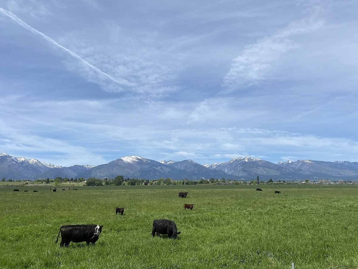
Photo: Rangeland and the Bitterroot Mountains near Hamilton: photo by Anthromesimages, CC BY-SA 4.0, via Wikimedia Commons, resized. All photo credits.

Last updated: November 2026
Part of our Montana towns guide. Moving here? Start with the Moving to Montana checklist.
Disclosure: We may earn a commission if you use some links on this page, at no extra cost to you.
Hamilton is the county seat of Ravalli County (Montana Association of Counties) and the main town of the Bitterroot Valley in southwest Montana. It sits at about 3,570 feet, between the Bitterroot Range to the west and the Sapphire Mountains to the east (NIAID Rocky Mountain Laboratories). Montana’s tourism office calls it the central trade area for the hundreds of small farms, ranches and orchards that fill the valley (Visit Montana). The nearest commercial airport is Missoula Montana Airport (MSO), about 51 road miles north. Glacier and Yellowstone are both long drives from here: roughly 4 hours to Glacier’s West Entrance and about 5½ hours to Yellowstone’s Montana entrances.
This page covers the quick facts people search for, then getting here, things to do, weather and costs. For the nearest big housing market, see Cost of Living in Missoula.
Hamilton quick facts
| Fact | Answer | Source |
|---|---|---|
| County | Ravalli County (county seat) | USGS GNIS (feature 784496); Montana Association of Counties |
| Elevation | About 3,570 ft at the town’s official map point | USGS Elevation Point Query Service at the GNIS point |
| Population | 5,451 (July 1, 2025 estimate); 4,659 at the 2020 Census | Census QuickFacts |
| Nearest commercial airport | Missoula Montana Airport (MSO). About 51 road miles / 1 hr 10 min (route estimate) | MSO; OSRM route estimate |
| Nearest Glacier entrance | West Entrance (West Glacier), about 182 road miles | OSRM route estimate |
| Nearest Yellowstone entrance | West Entrance (West Yellowstone), about 250 road miles; closed to regular cars in winter | OSRM route estimate; NPS Park Roads |
| Main highway | U.S. 93 | MDT 511 |
Drive times from Hamilton
These are routing estimates from downtown Hamilton in clear conditions, with no stops and no entrance lines. Winter weather, construction and wildlife on the road add time.
| From downtown Hamilton to | Road miles | Approx. drive time | Season note | Source |
|---|---|---|---|---|
| Missoula Montana Airport (MSO) | ~51 mi | ~1 hr 10 min | U.S. 93 north | OSRM estimate |
| Missoula (downtown) | ~47 mi | ~1 hr | U.S. 93 north | OSRM estimate |
| Glacier West Entrance (West Glacier) | ~182 mi | ~4 hr 5 min | Going-to-the-Sun Road’s alpine section is seasonal | OSRM estimate; NPS Glacier Directions |
| Glacier St. Mary Entrance (east side) | ~267 mi | ~5 hr 45 min | Router’s route stays outside the park | OSRM estimate |
| Yellowstone West Entrance (West Yellowstone) | ~250 mi | ~5 hr 25 min | Closed to regular cars in winter | OSRM estimate; NPS Park Roads |
| Yellowstone North Entrance (Gardiner) | ~264 mi | ~5 hr 25 min | Open to cars year-round | OSRM estimate; NPS Park Roads |
| Big Hole National Battlefield | ~64 mi | ~1 hr 25 min | OSRM estimate; NPS | |
| Corvallis | ~6 mi | ~10 min | OSRM estimate | |
| Darby | ~17 mi | ~20 min | U.S. 93 south | OSRM estimate |
| Stevensville | ~20 mi | ~30 min | OSRM estimate | |
| Kalispell | ~167 mi | ~3 hr 35 min | OSRM estimate | |
| Bozeman | ~188 mi | ~4 hr 5 min | OSRM estimate |
Estimates come from the public OSRM router using OpenStreetMap geocodes for each place, checked November 1, 2026. Treat every figure as approximate, and check MDT 511 for road conditions before winter drives.
Planning a park trip from the Bitterroot? See the Glacier trip planner and Yellowstone from Montana, which explains which entrances stay open to cars in winter.
Getting to Hamilton
Fly. Missoula Montana Airport (MSO) is the nearest commercial airport. Its airlines page lists Alaska, Allegiant, American, Delta and United as year-round carriers, and Sun Country as seasonal (MSO Airlines + Destinations). Routes change, so check the airport’s site before booking.
Rent a car. MSO says seven major rental agencies have counters in its baggage claim area, with more off-site options that may run shuttles (MSO Rental Cars). From the airport it’s about 1 hour 10 minutes south on U.S. 93 to Hamilton. You can compare rental cars at Missoula’s airport (MSO).
Things to do in and near Hamilton
- Daly Mansion. Copper king Marcus Daly bought an existing homestead here in 1886 and remodeled it several times; the Georgian Revival home seen today was finished in 1910. The Daly Mansion Preservation Trust says it has more than 50 rooms, 25 bedrooms and 15 bathrooms across 24,000 square feet, and it first opened to the public in 1987 (Daly Mansion history). The State of Montana leases the mansion and about 46 acres of grounds to the Trust (Daly Mansion). In fall and winter the site posts weekday grounds hours and private tours by reservation, so call ahead before you go (Daly Mansion).
- Ravalli County Museum. It’s in the original Ravalli County Courthouse, built in 1900 and listed on the National Register (Visit Montana). The museum focuses on art, local history and natural history (Ravalli County Museum).
- Blodgett Canyon. The Forest Service trailhead is a few miles west of town via Ricketts Road and Blodgett Camp Road (FS 736). Blodgett Creek Trail #19 runs 12.6 miles up a granite-walled canyon with cliffs more than 2,000 feet high. For a shorter outing, the Blodgett Overlook Trail is about a 2.9-mile round trip with roughly 500 feet of climbing. The Forest Service lists no fee at the Blodgett trailhead, and access depends on snow (USFS Blodgett Trailhead; Blodgett Creek Trail #19; Blodgett Overlook Trail #101).
- Lake Como. About 16 miles south of Hamilton off U.S. 93, this Forest Service irrigation reservoir covers about 980 acres, with a sandy swim beach, campgrounds, a boat launch and an 8-mile loop trail. A recreation pass is required from Memorial Day to Labor Day, and the Forest Service says the lake is usually fullest from spring through late July (USFS Lake Como Recreation Area; Lake Como Campground).
- Rocky Mountain Laboratories. This NIH research campus in Hamilton grew out of Rocky Mountain spotted fever research that began in the valley around 1900; its first building was finished in 1928 (NIAID).
- Lee Metcalf National Wildlife Refuge. A 2,800-acre refuge on the Bitterroot River about 2 miles north of Stevensville (U.S. Fish & Wildlife Service). Stevensville is about 20 road miles north of Hamilton.
- Big Hole National Battlefield. The National Park Service site is on Highway 43, ten miles west of Wisdom (NPS), about 64 road miles from Hamilton.
- Hot springs. Lolo Hot Springs, on U.S. 12 west of Lolo, is about 61 road miles away. See the Montana hot springs guide for pool temperatures and other soaks.
Weather at a glance
NOAA’s 1991–2020 climate normals for the Hamilton station (monthly, annual):
| Month | Avg. high | Avg. low | Avg. precipitation |
|---|---|---|---|
| January | 35°F | 19°F | 0.96 in |
| April | 56°F | 31°F | 1.12 in |
| July | 84°F | 50°F | 0.85 in |
| October | 57°F | 31°F | 0.94 in |
| December | 34°F | 18°F | 1.33 in |
Annual precipitation is about 13.6 inches (rain plus melted snow), drier than Kalispell’s roughly 16.8. NOAA doesn’t publish a snowfall normal for this station, so we’ve left snowfall out rather than guess. Month guides: Montana in December and Montana in January.
Living in Hamilton: people and costs
Hamilton is small but growing. The Census Bureau estimates 5,451 residents for July 2025, up 16.3% from the 2020 estimates base; the 2020 Census counted 4,659. About 34.3% of residents are 65 or older, and the average commute is 12.2 minutes (Census QuickFacts).
| ACS 2020–2024 | Hamilton | Source |
|---|---|---|
| Median value, owner-occupied home | $310,000 | Census QuickFacts |
| Median gross rent | $947 | Same |
| Median household income | $49,204 | Same |
ACS figures are five-year averages and run behind the market, and the income figure partly reflects the large retired population. We don’t have a full Hamilton cost guide yet; the Missoula cost of living guide covers the nearest big market. Moving from out of state? Use the Moving to Montana checklist, and see Does Montana have sales tax? for how taxes work here.
Where to stay
If you’re flying in and out of MSO, you could stay in Missoula, about an hour north: compare hotels in Missoula on Expedia. Lodging in Montana pays the 8% state lodging tax (MT DOR).
Nearby towns
- Missoula, about 47 road miles north. Western Montana’s river city and home of the University of Montana.
- Butte, southeast over the mountains; drive time depends a lot on route and season.
- Kalispell, about 167 road miles north, for the Flathead Valley and Glacier’s west side.
- See all Montana towns
Frequently asked questions
What county is Hamilton, Montana in?
Ravalli County. Hamilton is the county seat (USGS GNIS; Montana Association of Counties).
What is the elevation of Hamilton, MT?
About 3,570 feet at the town’s official USGS map point (USGS Elevation Point Query Service).
What is the closest airport to Hamilton, Montana?
Missoula Montana Airport (MSO), about 51 road miles, or roughly 1 hour 10 minutes, north on U.S. 93 (MSO; OSRM route estimate).
How far is Hamilton from Missoula?
About 47 road miles from downtown to downtown, roughly an hour by car (OSRM route estimate).
How far is Hamilton from Glacier National Park?
About 182 road miles to the West Entrance at West Glacier, roughly 4 hours by car. The east-side St. Mary Entrance is about 267 road miles, roughly 5 hours 45 minutes (OSRM route estimates).
How far is Hamilton from Yellowstone?
About 250 road miles, roughly 5 hours 25 minutes, to the West Entrance at West Yellowstone, which is closed to regular cars in winter. The North Entrance at Gardiner, open to cars all year, is about 264 miles, also roughly 5 hours 25 minutes (OSRM route estimates; NPS Park Roads).
Is the Daly Mansion open in winter?
The mansion’s site lists fall and winter (October–December) grounds hours on weekdays and says walk-in mansion tours are closed then; private tours are by reservation, booked 48–72 hours ahead by phone (Daly Mansion). Check the site for current hours.
Sources
- Montana Association of Counties, county seats: https://www.mtcounties.org/about-counties/county-seats/
- USGS GNIS Domestic Names, Montana (feature 784496): https://prd-tnm.s3.amazonaws.com/StagedProducts/GeographicNames/DomesticNames/DomesticNames_MT_Text.zip
- USGS Elevation Point Query Service: https://epqs.nationalmap.gov/v1/docs
- U.S. Census Bureau QuickFacts (Vintage 2025 estimates; 2020 Census; ACS 2020–2024): https://www.census.gov/quickfacts/fact/table/greatfallscitymontana,buttesilverbowbalancemontana,livingstoncitymontana,polsoncitymontana,hamiltoncitymontana,MT/PST045225
- Visit Montana, Hamilton: https://www.visitmt.com/places-to-go/cities-and-towns/hamilton
- Missoula Montana Airport: https://flymissoula.com/ ; https://flymissoula.com/airlines-destinations ; https://flymissoula.com/rental-cars
- Daly Mansion: https://www.dalymansion.org/ ; https://dalymansion.org/about/ ; https://dalymansion.org/history-and-preservation/
- Ravalli County Museum: https://ravallimuseum.org/
- USDA Forest Service, Bitterroot National Forest (Blodgett Trailhead, Blodgett Creek Trail #19, Blodgett Overlook Trail #101, Lake Como Recreation Area and Campground)
- NIAID, Rocky Mountain Laboratories: https://www.niaid.nih.gov/about/rocky-mountain-laboratories
- U.S. Fish & Wildlife Service, Lee Metcalf NWR: https://www.fws.gov/refuge/lee-metcalf
- NPS Big Hole National Battlefield: https://www.nps.gov/biho/ ; NPS Yellowstone Park Roads: https://www.nps.gov/yell/planyourvisit/parkroads.htm ; NPS Glacier Directions: https://www.nps.gov/glac/planyourvisit/directions.htm
- NOAA NCEI 1991–2020 normals, station USC00243885 (Hamilton)
- Montana Department of Revenue, lodging facility tax: https://revenue.mt.gov/taxes/miscellaneous/lodging-facility
- Drive times: OSRM public router with OpenStreetMap/Nominatim geocodes, Nov. 1, 2026
Cole Bennett edits MontanaHelp, a research-driven guide to moving to and living in Montana. Articles cite official and public sources and are updated as rules and data change. AI tools help research and draft them; a person runs the editorial process and spot-checks one article per batch before it’s published.
AI tools helped research and draft this article. A person runs MontanaHelp’s editorial process and spot-checks one article per batch before it’s published.
This page is general information, not financial, tax, safety or legal advice. Confirm road status, hours and fees with the linked official sources.