
Missoula, Montana
Western Montana’s river city and home of the University of Montana.
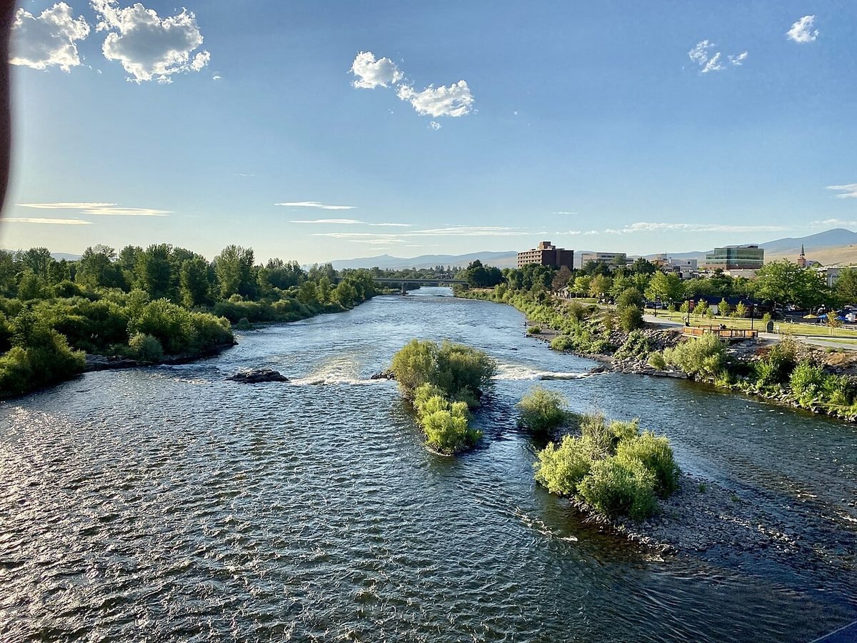
Photo: Clark Fork River, Missoula: photo by w_lemay, CC BY-SA 2.0, via Wikimedia Commons, resized. All photo credits.

Last updated: October 28, 2026
Part of our Montana towns guide. Heading to the park? See the Glacier trip planner.
Disclosure: We may earn a commission if you use some links on this page, at no extra cost to you.
Missoula is the county seat of Missoula County (Montana Association of Counties) and home to the University of Montana. The town sits at about 3,210 feet on the Clark Fork River. Downtown is roughly 137 road miles (about 3 hours) from Glacier National Park’s West Entrance and about 264–278 road miles (roughly 4 hours 35 minutes to 4 hours 40 minutes) from Yellowstone’s Montana entrances. That makes Missoula a reasonable fly-in or stopover point for Glacier, and a long day’s drive from Yellowstone.
This page covers the quick facts people search for, then getting here, getting around, things to do, weather and costs. For the full money picture, see Cost of Living in Missoula.
Missoula quick facts
| Fact | Answer | Source |
|---|---|---|
| County | Missoula County (county seat) | USGS GNIS (feature 787504); Montana Association of Counties |
| Elevation | About 3,210 ft at the town’s official map point | USGS Elevation Point Query Service at the GNIS point |
| Population | 78,903 (July 1, 2025 estimate); 73,489 at the 2020 Census | Census QuickFacts |
| Nearest commercial airport | Missoula Montana Airport (MSO). About 6 road miles / 12 min from downtown (route estimate) | MSO; OSRM route estimate |
| Nonstop markets | The airport advertises nonstop flights to 13–14 U.S. markets (its homepage shows both figures) | MSO |
| University | University of Montana | University of Montana |
| Interstate | I-90 | Montana Snowbowl (“Interstate 90 skirts the edge of Missoula”) |
Drive times from Missoula to Glacier and Yellowstone
These are routing estimates from downtown Missoula in clear conditions, with no stops and no entrance lines. Winter weather, construction and wildlife on the road add time.
| From downtown Missoula to | Road miles | Approx. drive time | Season note | Source |
|---|---|---|---|---|
| Glacier West Entrance (West Glacier) | ~137 mi | ~3 hr | West side; Going-to-the-Sun Road alpine section is seasonal | OSRM estimate; NPS Glacier Directions |
| Glacier St. Mary Entrance (east side) | ~222 mi | ~4 hr 45 min | East side | OSRM estimate; NPS Glacier Directions |
| Yellowstone West Entrance (West Yellowstone) | ~264 mi | ~4 hr 35 min | Closed to regular cars in winter | OSRM estimate; NPS Park Roads |
| Yellowstone North Entrance (Gardiner) | ~278 mi | ~4 hr 40 min | Open to cars year-round | OSRM estimate; NPS Park Roads |
| Hamilton | ~47 mi | ~1 hr | US 93 south up the Bitterroot Valley | OSRM estimate |
| Polson (Flathead Lake) | ~70 mi | ~1 hr 30 min | US 93 north | OSRM estimate |
| Kalispell | ~122 mi | ~2 hr 30 min | US 93 north | OSRM estimate |
| Butte | ~119 mi | ~2 hr | I-90 east | OSRM estimate |
| Bozeman | ~202 mi | ~3 hr 20 min | I-90 east | OSRM estimate |
Estimates come from the public OSRM router using OpenStreetMap geocodes for each town, checked October 28, 2026. The National Park Service puts Missoula’s airport about 150 miles south of Glacier’s West Entrance (NPS Glacier Directions). Treat every figure as approximate.
For Glacier timing, see Best Time to Visit Glacier. Entry and shuttle rules can change from year to year, so check the NPS Glacier news page before you go. If you’d rather not drive the park yourself, there’s a guided west-side Glacier driving tour from West Glacier. Check the listing’s itinerary and season before you book. For Yellowstone, start with Yellowstone from Montana; most park roads close to regular cars in winter, and Yellowstone in Winter from Montana explains the oversnow season.
Getting to Missoula
Fly. MSO is on the west side of town. Its airlines page lists year-round service on Alaska (Portland, Seattle), Allegiant (Las Vegas, Phoenix/Mesa), American (Chicago O’Hare, Dallas/Fort Worth) and Delta (Salt Lake City, Minneapolis), plus seasonal routes (MSO Airlines + Destinations). Routes change, so check that page before booking. The airport says the first phase of its new terminal opened in June 2022 and a second phase is under way, with more gates, a bigger baggage claim and a rental car center (MSO).
Rent a car. MSO lists on-site counters for Alamo, Avis, Budget, Enterprise, Hertz, National and Thrifty, open from 6 a.m. to the last arrival (MSO Rental Cars). If you’re driving on to Glacier or the Bitterroot, compare rental cars at Missoula’s airport (MSO). In winter, check road conditions on MDT 511 before mountain passes.
Ground options. The airport lists local taxi and shuttle companies, Uber and Lyft, and Mountain Line buses; it notes many hotels run their own airport shuttles (MSO Ground Transportation).
Getting around
Mountain Line buses are free. The system went zero-fare in January 2015, and it says it now provides more than 1.5 million rides a year (Mountain Line Zero-Fare). It runs 12 fixed routes across about 70 square miles of the Missoula Valley, with door-to-door paratransit too (Mountain Line History & Facts).
Things to do in and near Missoula
- Montana Snowbowl. A ski area about 20 minutes north of downtown off I-90 Exit 101 and Grant Creek Road (Montana Snowbowl). It’s on the Indy Pass, which lists 2,600 feet of vertical (Indy Pass). Lost Trail is about 90 miles south and Discovery is farther afield; compare them in Montana Ski Resorts Compared.
- University of Montana. The university’s campus is in Missoula; see the university for campus events and visitor information.
- The rivers. The Clark Fork River runs through downtown, and the city says its riverfront trail follows the river there (City of Missoula). Before fishing or floating, check licenses, rules and access sites with Montana Fish, Wildlife & Parks.
- Hot springs. See the Montana hot springs guide for developed soaks around the state.
- Glacier and Flathead Lake. US 93 north takes you past Flathead Lake toward Kalispell and the park.
Weather at a glance
NOAA’s 1991–2020 climate normals for the Missoula International Airport station (monthly, annual):
| Month | Avg. high | Avg. low |
|---|---|---|
| January | 32°F | 18°F |
| April | 56°F | 32°F |
| July | 85°F | 52°F |
| October | 56°F | 32°F |
| December | 31°F | 18°F |
Annual precipitation is about 14 inches (rain plus melted snow), and annual snowfall is about 43 inches, roughly half of Bozeman’s. Month guides: Montana in December and Montana in January.
Living in Missoula: people and costs
The Census Bureau estimates 78,903 residents for July 2025, up from 73,489 at the 2020 Census (Census QuickFacts).
| ACS 2020–2024 | Missoula | Source |
|---|---|---|
| Median value, owner-occupied home | $473,100 | Census QuickFacts |
| Median gross rent | $1,189 | Same |
| Median household income | $70,392 | Same |
| Owner-occupied housing rate | 47.0% | Same |
A little over half of households rent. ACS figures are five-year averages and run behind the market. Missoula’s median home value is above Montana’s overall ($375,800) and well below Bozeman’s $687,900 (both from Census QuickFacts; see our Bozeman town guide). For Zillow values, rents, wages, utilities and property tax, read Cost of Living in Missoula. Moving from out of state? Start with Moving to Montana in 2027 and the Moving to Montana checklist.
Where to stay
Missoula works as an overnight stop on the way to Glacier, about 3 hours from the West Entrance. Compare hotels in Missoula on Expedia. If you’d rather sleep next to the park, compare hotels in West Glacier on Expedia or read Where to Stay Near Glacier. Lodging in Montana pays the 8% state lodging tax (MT DOR).
Nearby towns
- Hamilton, about 47 road miles south. Ravalli County seat.
- Polson, about 70 road miles north, on Flathead Lake.
- Kalispell, about 122 road miles north. Glacier Park International Airport is near Kalispell, about 30 miles from the West Entrance (NPS).
- Butte, about 119 road miles east. Mining history and the Uptown district.
- See all Montana towns
Frequently asked questions
What county is Missoula, Montana in?
Missoula County. The city of Missoula is the county seat (USGS GNIS; Montana Association of Counties).
What is the elevation of Missoula, MT?
About 3,210 feet at the town’s official USGS map point (USGS Elevation Point Query Service). Elevation varies across the valley and rises fast on the surrounding hills.
What is the closest airport to Missoula?
Missoula Montana Airport (MSO), about 6 road miles, or roughly 12 minutes, from downtown (MSO; OSRM route estimate).
How far is Missoula from Glacier National Park?
About 137 road miles, or roughly 3 hours, to the West Entrance at West Glacier, and about 222 miles, roughly 4 hours 45 minutes, to St. Mary on the east side (OSRM route estimates; NPS Glacier Directions). Glacier Park International Airport, near Kalispell, is much closer to the park, about 30 miles from the West Entrance per NPS.
How far is Missoula from Yellowstone?
About 264 road miles, roughly 4 hours 35 minutes, to the West Entrance at West Yellowstone, which is closed to regular cars in winter. The North Entrance at Gardiner, open to cars all year, is about 278 miles, roughly 4 hours 40 minutes (OSRM route estimates; NPS Park Roads).
Is the bus free in Missoula?
Yes. Mountain Line has been zero-fare since 2015 (Mountain Line).
Sources
- Montana Association of Counties, county seats: https://www.mtcounties.org/about-counties/county-seats/
- USGS GNIS Domestic Names, Montana (feature 787504): https://prd-tnm.s3.amazonaws.com/StagedProducts/GeographicNames/DomesticNames/DomesticNames_MT_Text.zip
- USGS Elevation Point Query Service: https://epqs.nationalmap.gov/v1/docs
- U.S. Census Bureau QuickFacts (Vintage 2025 estimates; 2020 Census; ACS 2020–2024): https://www.census.gov/quickfacts/fact/table/bozemancitymontana,missoulacitymontana,kalispellcitymontana,whitefishcitymontana,billingscitymontana,helenacitymontana/PST045225
- Missoula Montana Airport: https://flymissoula.com/ ; /airlines-destinations/ ; /rental-cars/ ; /ground-transportation/
- University of Montana: https://www.umt.edu/about/
- Mountain Line: https://mountainline.com/sustainability/zero-fare/ ; https://mountainline.com/about/history-facts/
- Montana Snowbowl: https://montanasnowbowl.com/sbblog/contact-us/ ; Indy Pass: https://www.indyskipass.com/our-resorts
- NPS Glacier Directions: https://www.nps.gov/glac/planyourvisit/directions.htm ; NPS Yellowstone Park Roads: https://www.nps.gov/yell/planyourvisit/parkroads.htm
- NOAA NCEI 1991–2020 normals, station USW00024153
- Montana Department of Revenue, lodging facility tax: https://revenue.mt.gov/taxes/miscellaneous/lodging-facility
- Drive times: OSRM public router with OpenStreetMap geocodes for each town, Oct. 28, 2026
- City of Missoula, Riverfront Trail System: https://www.ci.missoula.mt.us/Facilities/Facility/Details/84
- NPS Glacier news: https://www.nps.gov/glac/learn/news/index.htm
Cole Bennett edits MontanaHelp, a research-driven guide to moving to and living in Montana. Articles cite official and public sources and are updated as rules and data change. AI tools help research and draft them; a person runs the editorial process and spot-checks one article per batch before it’s published.
AI tools helped research and draft this article. A person runs MontanaHelp’s editorial process and spot-checks one article per batch before it’s published.
This page is general information, not financial, tax, safety or legal advice. Confirm road status, hours and fees with the linked official sources.