
Butte, Montana
Copper-mining history, a Victorian Uptown and Montana’s biggest St. Patrick’s Day.
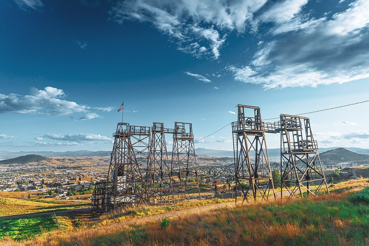
Photo: Mine headframes above Butte: photo by Nils Huenerfuerst, CC BY 4.0, via Wikimedia Commons, resized. All photo credits.

Last updated: October 2026
Butte started as a mining camp on the Continental Divide in 1864. Around the turn of the 20th century it was one of the largest copper boom towns in the American West (Wikipedia). In 1977 the city and Silver Bow County merged into one government, Butte-Silver Bow (Wikipedia). Mine headframes still stand among the houses, and the town wears its history proudly.
Quick facts
| County | Silver Bow County (consolidated city-county of Butte-Silver Bow) |
|---|---|
| Population | 35,469 (July 1, 2025 Census estimate); 34,494 at the 2020 Census. Figures are for Butte-Silver Bow (balance). |
| Elevation | About 5,540 feet |
| Nearest commercial airport | Bert Mooney Airport (BTM), about 9 miles straight-line |
| Distance to Helena | About 57 miles straight-line |
| Climate station | NOAA: Butte Bert Mooney Airport |
Sources: county from USGS GNIS; population from Census QuickFacts; elevation from the USGS Elevation Point Query Service at the town’s GNIS map point. Straight-line distances are calculated from Census Gazetteer town coordinates and OurAirports airport coordinates. Driving distances are longer.
What it’s like to live here
The Census Bureau estimates 35,469 residents for July 2025 in Butte-Silver Bow (balance), up from 34,494 at the 2020 Census (Census QuickFacts). That’s the consolidated city-county, minus the separate town of Walkerville.
The Irish community is a big part of local identity. As of 2017, Butte had the largest population of Irish Americans per capita of any U.S. city (Wikipedia). Uptown, on the hillside, is full of Victorian homes and ornate buildings from the mining era (Wikipedia). This is also a town of homeowners: 70.7% of homes are owner-occupied, compared with 69.2% statewide (QuickFacts).
Things to do and see
- St. Patrick’s Day. Butte has celebrated it since 1882, and about 30,000 people come to Uptown for the parade (Wikipedia).
- Montana Folk Festival. A regional festival held the second weekend of July. It began as the National Folk Festival in 2008 (Wikipedia).
- Evel Knievel Days. A celebration of the Butte-born daredevil, held the last weekend of July in Uptown (Wikipedia).
- World Museum of Mining. Set on the inactive Orphan Girl silver and zinc mine, with 50 buildings on about 22 acres (Wikipedia).
- The Berkeley Pit. A former open-pit copper mine about a mile long, now partly filled with acidic, metal-laden water. Mining there ended in 1982 (Wikipedia).
Getting around and weather
Interstates 15 and 90 cross in Butte. Every highway out of town except westbound I-90 crosses the Continental Divide (Wikipedia). Bert Mooney Airport has Delta Connection flights, the Butte Bus system runs local routes, and Jefferson Lines and Salt Lake Express provide intercity buses (Wikipedia). Butte is high and cold. The airport’s average January low is 7.9°F, the coldest in this guide (NOAA, below).
Weather at a glance. These are NOAA’s 1991–2020 climate normals for the Butte Bert Mooney Airport station (monthly, annual):
- January: average high 32°F, average low 8°F
- July: average high 81°F, average low 46°F
- Precipitation: 12.8 inches a year (rain plus melted snow)
NOAA doesn’t publish a snowfall normal for this station, so we’ve left snowfall out rather than guess.
Cost of living and housing
ACS 2020–2024 figures: median home value $257,800, median gross rent $856 and median household income $61,857 (QuickFacts). Butte’s housing is among the least expensive of any town in this guide.
We don’t have a full Butte cost-of-living guide yet. For moving costs and taxes, start with Moving to Montana in 2027.
ACS figures are 5-year averages (2020–2024) and lag the current market. This page is general information, not financial advice.
Nearby towns
- Helena, about 57 miles straight-line. The state capital, born in a gold rush on Last Chance Gulch.
- Hamilton, about 76 miles straight-line. Bitterroot Valley county seat with the Daly Mansion and canyon trailheads.
- Bozeman, about 79 miles straight-line. University town with ski hills on both sides and Yellowstone down the road.
- Missoula, about 94 miles straight-line. Western Montana’s river city and home of the University of Montana.
Sources
- U.S. Census Bureau QuickFacts: Great Falls, Butte-Silver Bow (balance), Livingston, Polson, Hamilton and Montana (Vintage 2025 population estimates; 2020 Census; ACS 2020–2024)
- U.S. Geological Survey, Geographic Names Information System (GNIS), Montana domestic names file (county and map coordinates)
- U.S. Geological Survey, Elevation Point Query Service (3DEP elevation at the GNIS map point)
- U.S. Census Bureau, 2024 Gazetteer file for Montana places (coordinates used for straight-line distances)
- OurAirports open data, airports with scheduled service in Montana (airport coordinates)
- NOAA NCEI, U.S. Climate Normals 1991–2020, Butte Bert Mooney Airport station (USW00024135): monthly normals
- NOAA NCEI, U.S. Climate Normals 1991–2020, Butte Bert Mooney Airport station (USW00024135): annual normals
- Wikipedia: Butte, Montana
- Wikipedia: World Museum of Mining
- Wikipedia: Berkeley Pit
All sources accessed October 21, 2026. Wikipedia is used for general background, history and attractions. For numbers, we link the official data source wherever one exists.