
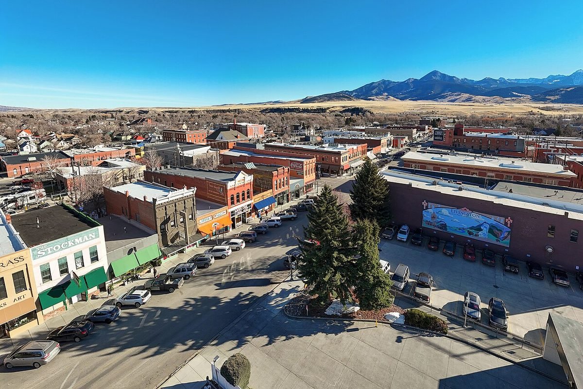
Livingston, Montana
Yellowstone’s original gateway town, on the Yellowstone River at the top of Paradise Valley.
Photo: Downtown Livingston from above: photo by Quintin Soloviev, CC BY 4.0, via Wikimedia Commons, resized. All photo credits.

Last updated: November 2026
Part of our Montana towns guide. Moving here? Start with the Moving to Montana checklist.
Disclosure: We may earn a commission if you use some links on this page, at no extra cost to you.
Quick answer: Livingston, Montana is the county seat of Park County. The Census Bureau’s latest estimate is 9,290 residents (July 1, 2025), up from 8,040 at the 2020 Census; no 2026 estimate has been published yet. The town sits at about 4,500 feet, about 38 road miles from Bozeman’s airport (BZN).
Livingston is the county seat of Park County (Montana Association of Counties) in south-central Montana. It sits at about 4,500 feet on the Yellowstone River, where Interstate 90 meets U.S. 89 (Park County). The county calls it the original gateway to Yellowstone National Park: the Northern Pacific Railroad reached Livingston in November 1882 and finished its National Park branch the next year (Park County history). The nearest commercial airport is Bozeman Yellowstone International (BZN), about 38 road miles west. Yellowstone’s year-round North Entrance at Gardiner is roughly an hour south through Paradise Valley; Glacier is a long day’s drive, about 6½ hours.
This page covers the quick facts people search for, then getting here, things to do, the wind, weather and costs. For the neighboring housing market, see Cost of Living in Bozeman.
Livingston quick facts
| Fact | Answer | Source |
|---|---|---|
| County | Park County (county seat) | USGS GNIS (feature 773511); Montana Association of Counties |
| Elevation | About 4,500 ft at the town’s official map point | USGS Elevation Point Query Service at the GNIS point |
| Population | 9,290 (July 1, 2025 estimate; no 2026 estimate published yet); 8,040 at the 2020 Census | Census QuickFacts |
| Nearest commercial airport | Bozeman Yellowstone International (BZN). About 38 road miles / 50 min (route estimate) | BZN; OSRM route estimate |
| Nearest Yellowstone entrance | North Entrance (Gardiner), about 52 road miles; open to cars year-round | OSRM route estimate; NPS Park Roads |
| Nearest Glacier entrance | St. Mary (east side), about 327 road miles; West Entrance about 354 | OSRM route estimate |
| Main highways | Interstate 90 and U.S. 89 | Park County |
Drive times from Livingston
These are routing estimates from downtown Livingston in clear conditions, with no stops and no entrance lines. Wind, winter weather, construction and wildlife on the road add time.
| From downtown Livingston to | Road miles | Approx. drive time | Season note | Source |
|---|---|---|---|---|
| Bozeman Yellowstone Int’l Airport (BZN) | ~38 mi | ~50 min | I-90 west over Bozeman Pass | OSRM estimate |
| Bozeman (downtown) | ~26 mi | ~35 min | I-90 west | OSRM estimate |
| Yellowstone North Entrance (Gardiner) | ~52 mi | ~1 hr | U.S. 89 south; open to cars year-round | OSRM estimate; NPS Park Roads |
| Cooke City (Northeast Entrance) | ~109 mi | ~2 hr 45 min | Route runs through the park via the North Entrance and Lamar Valley, the one road kept open to cars all winter | OSRM estimate; NPS Park Roads |
| Yellowstone West Entrance (West Yellowstone) | ~117 mi | ~2 hr 25 min | Via Bozeman and U.S. 191; entrance closed to regular cars in winter | OSRM estimate; NPS Park Roads |
| Big Sky | ~72 mi | ~1 hr 30 min | Via Bozeman and U.S. 191 | OSRM estimate |
| Big Timber | ~35 mi | ~40 min | I-90 east | OSRM estimate |
| Emigrant (Paradise Valley) | ~24 mi | ~30 min | U.S. 89 south | OSRM estimate |
| Billings | ~118 mi | ~2 hr 5 min | I-90 east | OSRM estimate |
| Helena | ~123 mi | ~2 hr 20 min | OSRM estimate | |
| Red Lodge | ~123 mi | ~2 hr 15 min | OSRM estimate | |
| Glacier St. Mary Entrance (east side) | ~327 mi | ~6 hr 20 min | Router’s route stays outside the park | OSRM estimate |
| Glacier West Entrance (West Glacier) | ~354 mi | ~6 hr 25 min | Going-to-the-Sun Road’s alpine section is seasonal | OSRM estimate; NPS Glacier Directions |
Estimates come from the public OSRM router using OpenStreetMap geocodes for each place, checked November 2, 2026. Treat every figure as approximate, and check MDT 511 for road and wind conditions before you drive.
Most park roads close to regular cars from early November to late April. The road from the North Entrance at Gardiner through the park to Cooke City is the only one generally open to cars all year (NPS Park Roads). See Yellowstone from Montana and Yellowstone in Winter from Montana, or start at our Yellowstone hub. Going north to Glacier? The Glacier trip planner covers the park.
Getting to Livingston
Fly. Bozeman Yellowstone International Airport (BZN) is the nearest commercial airport. It says it serves the Bozeman, Belgrade and Livingston area and has nonstop flights to more than 20 U.S. cities (BZN). Routes change by season, so check the airport’s site before booking. Billings Logan International (BIL) is the other option, about 120 road miles east (OSRM estimate).
Rent a car. BZN says eight major rental-car agencies have offices right next to baggage claim (BZN Ground Transportation). From the airport it’s about 50 minutes east to Livingston on I-90. You can compare rental cars at Bozeman’s airport (BZN). On windy days, the National Weather Service warns that crosswinds on the interstate can be hazardous for high-profile vehicles (see the wind section below).
Bus. Streamline runs weekday commuter bus service to Livingston (Streamline). Check its site for the current schedule.
Things to do in and near Livingston
- Livingston Depot Center. The depot was built in 1902 as the Northern Pacific’s launching point for travel to Yellowstone. It was designed by Reed & Stem, the original architects of New York’s Grand Central, and greeted rail passengers until 1979, when Amtrak ended passenger service to southern Montana. Burlington Northern donated it to the City of Livingston in 1985, and it reopened two years later after a restoration (Livingston Depot Center). Today its museum covers western history and art. In 2026 it was open Monday through Saturday from May 26 to September 4 and charges admission (Depot Museum); the depot says the museum is closed from about mid-September to mid-May (Depot FAQ).
- Yellowstone Gateway Museum. Park County’s museum at 118 W. Chinook St. has permanent exhibits on the county’s role as the historic gateway to Yellowstone, Native cultures, railroads, ranching and rodeo, plus an outdoor one-room schoolhouse, blacksmith shop and an original Northern Pacific caboose. It’s on the Lewis and Clark National Historic Trail and offers a passport cancellation stamp (Park County: Yellowstone Gateway Museum). Check the county page for current hours; we couldn’t confirm winter hours.
- Paradise Valley. The Yellowstone River valley runs south from Livingston toward Gardiner on U.S. 89. Park County says the river runs through the county from Gardiner to Springdale and draws anglers, floaters and wildlife watchers (Park County).
- Hot springs. Chico Hot Springs in Pray, in Paradise Valley, has two open-air pools and day passes; Yellowstone Hot Springs is near Gardiner. Our Montana hot springs guide has hours and pool temperatures from each resort.
- Year-round outdoors. Montana’s tourism office lists fly fishing, dogsledding, cross-country skiing, horseback riding and river rafting around town, along with museums, galleries and restaurants (Visit Montana).
- Wildlife in Yellowstone. The Lamar Valley sits on the park road that stays open to cars all winter. If you’d rather not drive it yourself, there’s a guided Hayden and Lamar Valley wildlife tour from Gardiner; check the listing for the dates it runs.
- Big mountains nearby. Park County is ringed by the Absaroka, Bridger, Gallatin and Crazy Mountains, and it holds Granite Peak, Montana’s highest point at 12,807 feet (Park County).
The wind
Livingston is known for wind, and the National Weather Service backs that up. The NWS Billings office says strong southwest winds are “very common” in Livingston in winter, caused by cold air draining off Yellowstone’s high plateau combined with strong westerly winds aloft. It notes that crosswinds often make interstate travel hazardous for high-profile vehicles, and that fresh snow can turn into blowing and drifting snow. On February 28, 2024, the Livingston airport measured a 92 mph gust, its second-strongest on record behind a 94 mph gust on December 21, 1978 (records date to 1973) (NWS Billings, Top 5 Weather Events of 2024). If you tow a trailer or drive a tall vehicle, check MDT 511 and NWS wind alerts before heading over Bozeman Pass.
Weather at a glance
NOAA’s 1991–2020 climate normals for the Livingston Mission Field station (monthly, annual):
| Month | Avg. high | Avg. low | Avg. precipitation |
|---|---|---|---|
| January | 37°F | 19°F | 0.44 in |
| April | 54°F | 30°F | 1.71 in |
| July | 86°F | 50°F | 1.31 in |
| October | 58°F | 33°F | 1.36 in |
| December | 36°F | 19°F | 0.50 in |
Annual precipitation is about 14.6 inches (rain plus melted snow), with May and June the wettest months. NOAA doesn’t publish a snowfall normal for this station, so we’ve left snowfall out rather than guess. Month guides: Montana in December and Montana in January.
Living in Livingston: people and costs
The Census Bureau estimates 9,290 residents for July 2025, up from 8,040 at the 2020 Census. The average commute is 25.5 minutes, about twice Hamilton’s 12.2 minutes (Census QuickFacts).
| ACS 2020–2024 | Livingston | Montana | Source |
|---|---|---|---|
| Median value, owner-occupied home | $392,400 | $375,800 | Census QuickFacts |
| Median gross rent | $1,046 | — | Same |
| Median household income | $65,861 | — | Same |
ACS figures are five-year averages and run behind the market. We don’t have a full Livingston cost guide yet; the Bozeman cost of living guide covers the neighboring market. Moving from out of state? Use the Moving to Montana checklist, and see Does Montana have sales tax? for how taxes work here.
Where to stay
Livingston is about an hour’s drive from Yellowstone’s North Entrance. Compare hotels in Livingston on Expedia. If you’d rather sleep at the park’s edge, compare hotels in Gardiner on Expedia. Groups can look at vacation rentals in Gardiner and Paradise Valley on Vrbo. Lodging in Montana pays the 8% state lodging tax (MT DOR).
Nearby towns
- Bozeman, about 26 road miles west over Bozeman Pass. University town, BZN airport and ski areas.
- Red Lodge, about 123 road miles southeast. Mountain town at the start of the Beartooth Highway.
- Helena, about 123 road miles northwest. The state capital.
- Billings, about 118 road miles east on I-90. Montana’s largest city.
- Gardiner, about 52 road miles south at Yellowstone’s North Entrance.
- To browse every town we’ve written up, see all Montana towns.
Frequently asked questions
What county is Livingston, Montana in?
Park County. Livingston is the county seat (USGS GNIS; Montana Association of Counties).
What is the population of Livingston, MT?
The Census Bureau’s most recent estimate is 9,290 residents for July 1, 2025. The 2020 Census counted 8,040. Census has not published a 2026 estimate for Livingston yet, so any “2026 population” figure is not an official count (Census QuickFacts, Livingston city, Montana).
What is the elevation of Livingston, MT?
About 4,500 feet at the town’s official USGS map point (USGS Elevation Point Query Service).
What is the closest airport to Livingston, Montana?
Bozeman Yellowstone International Airport (BZN), about 38 road miles, or roughly 50 minutes, west on I-90. The airport lists Livingston as part of the area it serves (BZN; OSRM route estimate).
How far is Livingston from Yellowstone?
About 52 road miles, roughly 1 hour, south on U.S. 89 to the North Entrance at Gardiner, the park’s only entrance with a road open to regular cars all year. The West Entrance at West Yellowstone is about 117 road miles, roughly 2 hours 25 minutes, and closes to regular cars in winter (OSRM route estimates; NPS Park Roads).
How far is Livingston from Glacier National Park?
About 327 road miles to the east-side St. Mary Entrance, roughly 6 hours 20 minutes, and about 354 road miles to the West Entrance at West Glacier, roughly 6 hours 25 minutes (OSRM route estimates; NPS Glacier Directions).
How far is Livingston from Bozeman?
About 26 road miles downtown to downtown, roughly 35 minutes over Bozeman Pass on I-90 (OSRM route estimate). Streamline runs weekday commuter bus service to Livingston (Streamline).
Why is Livingston so windy?
The National Weather Service says strong southwest winds are very common in winter, as cold air drains off Yellowstone’s high plateau under strong westerly winds aloft. The Livingston airport’s top recorded gust is 94 mph, set December 21, 1978 (NWS Billings).
Is the Livingston Depot museum open in winter?
No. The museum’s 2026 season ran May 26 to September 4, Monday through Saturday, and the depot says the museum is closed from about mid-September to mid-May (Depot Museum; Depot FAQ). The building still hosts winter events.
Sources
- Montana Association of Counties, county seats: https://www.mtcounties.org/about-counties/county-seats/
- USGS GNIS Domestic Names, Montana (feature 773511): https://prd-tnm.s3.amazonaws.com/StagedProducts/GeographicNames/DomesticNames/DomesticNames_MT_Text.zip
- USGS Elevation Point Query Service: https://epqs.nationalmap.gov/v1/docs
- U.S. Census Bureau QuickFacts (Vintage 2025 estimates; 2020 Census; ACS 2020–2024): https://www.census.gov/quickfacts/fact/table/greatfallscitymontana,buttesilverbowbalancemontana,livingstoncitymontana,polsoncitymontana,hamiltoncitymontana,MT/PST045225
- Park County, Montana: About (https://www.parkcountymt.gov/About/), History (https://www.parkcountymt.gov/History/), Yellowstone Gateway Museum (https://www.parkcountymt.gov/Yellowstone-Gateway-Museum/)
- Bozeman Yellowstone International Airport: https://www.bozemanairport.com/ ; https://www.bozemanairport.com/ground-transportation
- Streamline: https://streamlinebus.com/
- Livingston Depot Center: https://www.livingstondepot.org/ ; https://www.livingstondepot.org/museum.html ; https://www.livingstondepot.org/faqs.html
- Visit Montana, Livingston: https://www.visitmt.com/places-to-go/cities-and-towns/livingston
- NPS Yellowstone Park Roads: https://www.nps.gov/yell/planyourvisit/parkroads.htm ; NPS Glacier Directions: https://www.nps.gov/glac/planyourvisit/directions.htm
- National Weather Service Billings, Top 5 Weather Events of 2024: https://www.weather.gov/media/byz/2024_Top5WeatherEvents.pdf
- NOAA NCEI 1991–2020 normals, station USW00024150 (Livingston Mission Field)
- Montana Department of Revenue, lodging facility tax: https://revenue.mt.gov/taxes/miscellaneous/lodging-facility
- Drive times: OSRM public router with OpenStreetMap/Nominatim geocodes, Nov. 2, 2026
Cole Bennett edits MontanaHelp, a research-driven guide to moving to and living in Montana. Articles cite official and public sources and are updated as rules and data change. AI tools help research and draft them; a person runs the editorial process and spot-checks one article per batch before it’s published.
AI tools helped research and draft this article. A person runs MontanaHelp’s editorial process and spot-checks one article per batch before it’s published.
This page is general information, not financial, tax, safety or legal advice. Confirm road status, hours and fees with the linked official sources.